We miss our friend
April 2nd, 2008 11:44Amber is with Goldie.
Amber is with Goldie.
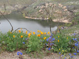
Visiting Lake Poway was one of Amber’s very first experiences with us. Amber, Shirley and I went to Lake Poway this morning to hike and take pictures in the early light. The wildflowers are still in wonderful bloom and we enjoyed them in the early morning stillness. We were pleased that Amber was her usual self, investigating and exploring. Shirley was taking pictures of Amber and of the scenery while she and I were quietly lost in our thoughts and reflections of the last three months. It was a very special time.
Blue Sky, which has been closed since the Witch Creek fire last October, opened today. Amber was excited to be going someplace new. Blue Sky is three houses and across Espola Road from our home and we were curious to see how much Blue Sky had come back after the fire. We’re extremely grateful for the firemen who held the fire at Espola Road.
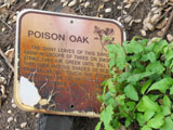
There were quite a few people, maybe 20 or so, hiking but not nearly as many as I expected on opening day. We decided to stay on the road above the creek rather than taking the trail alongside the creek which had much poison oak. The trail was visible from the road and everyone we saw was taking the road except for what appeared to be a Poway Community Services photographer. Everyone was friendly and seemed happy that Blue Sky was finally open.
A few days ago we started from the trail south from trail 14 at Del Pointe Road which trail is unmarked on the Poway Trail map and is likely either Avocado Trail (trail 14) or Tierra Bonita Trail (trail 19). We wanted to pick up the Twin Peaks Trail and follow it west to the creek near Midland Road and return. We walked south a while and then took what we thought was Twin Peaks Trail to the west. The trail went west but then bent around slowly to the north. We thought it might change back to the west so we kept going. However, it brought us back to a street just south of Del Pointe Road.
So, intent on determining where we had gone wrong, yesterday, we thought we would approach that unmarked (on the map) trail from the southern end at Twin Peaks trail. We took Tierra Bonita Trail south from Del Pointe near Espola Road to Twin Peaks Trail, then west across the creek near Midland Road and then north a short distance. We returned to Twin Peaks Trail and then turned on what we thought was the south end of the trail we had taken a few days before. We went due north, looking for any trail that might have led to the west but found none. The trail crossed a street and then became much narrower and continued due north above a creek to the west.
We went within a few of a large building that we thought was a house but weren’t sure because all we could see was one wall that had a couple of windows and no window treatment. As we passed the building we then saw the wall was the back of a very large house with an elaborate front yard. We were suddenly amongst very expensive homes but were unfamiliar with the neighborhood. The narrow trail came to a street and we looked to pick up the trail on the other side of the street but the trail apparently ended.
Rather than return from were we had come, we thought we would look for an intersection and find a sign with the street names. Well, we did that at the “T” street but that didn’t help much at this time. We could go either left or right so we chose to go right which would take us south. After about five minutes, Amber stopped and looked back at me as if to say, “Do you know where you’re going?” I told her, “Let’s go” so we continued on. She soon paused again, grabbed the leash in her mouth and started pulling to go back. I again convinced her to continue. We shortly came to the end of the street and I could see that Amber was right.
So, we went back to the “T” intersection and, as we walked back, I called Shirley for directions. Shirley thought it was quite funny for us to be lost in a neighborhood so close to home, got a map and gave me directions. As it turned out, we were about a couple of minutes south of Del Pointe Road and a very short distance to the car. The trail we had wanted was some distance to the west on Del Pointe Road. If we had not had the cell phone, we would have had another hour’s walk as we backtracked to the car.
Today, we’ll use Google Earth or Live Search Maps (aerial view) to attempt to see where we hiked. Many times it’s difficult to see the trails from the aerial views because the trees obscure the trails.
Next time we hike there, we’ll take a city map, trail map, paper, pen and camera in order to document our hike. However, we like that the trails are poorly marked and that there are many unmarked cross trails and trail spurs as that adds to the adventure. And, I’ve learned to listen to Amber!
 Amber and I took Old Coach Trail from the parking area just north of Espola Road to just past the point where Stoneridge? Trail meets Old Coach Trail to the fire-damaged bridge.
The lupine (lupin) was blooming and we saw it throughout the open areas but never in a mass. The beautiful blue alone would have made the hike worthwhile. I need to make it a habit to take my camera on these hikes. There’s always something attractive or interesting to photograph.
We turned around at the bridge. Someone had moved the “Trail Closed Ahead” sign from alongside the trail (Shirley’s 3/5/08 picture shown) to the south end of the bridge, somewhat blocking the trail. I thought it unsafe continuing over the bridge, as one of the beams had burned through and there was no convenient way of my determining other damage. Although Amber would have delighted in wading either across or downstream Sycamore Creek, it was more than what I wanted to undertake. Again, I had the urge to let Amber off-leash but didn’t. If only I could trust her to come when I called.
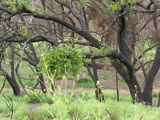
On the way back, we could for a while hear, but not see because of the trees, people across Sycamore Creek. The habitat is definitely showing signs of recovery from the Witch Creek fire. At points, there were flowers growing in the path and I took particular care to avoid stepping on them. Soon the water will run out and the foliage will again be brown until next year.
We heard a “gobble, gobble” ahead but the trail bended left and was obscured by brush and trees. Finally, we saw the turkey about 50 meters ahead on the left side of the trail and, as we approached, it moved down from the trail toward the creek, which was substantially below us. Amber was curious and wanted to get closer to the turkey, but not chase it, and a “let’s go” got her moving. She kept getting glimpses of the turkey until it finally disappeared in the brush.
We intend to always take the cell phone but forgot it today. I suppose I need to make a checklist that includes both the phone and camera to avoid a “senior moment”. As it gets warmer, we’ll need to include water, although Amber has been drinking from the creeks and streams. When she can, she laps the water as she moves through it, not stopping to drink. That’s the dingo in her!
 It is confusing! Is it Stoneridge Trail or Lomas Verde Trail? The trail markers say “Stoneridge” and the trail map says “Lomas Verdes”. I’m not sure that it matters as it’s a very nice hike in any event. Shirley and I repeated yesterday’s hike in the hopes of getting some great pictures of wildflowers but we were a couple of hours earlier than before and there was a thin cloud layer that blocked much of the sun so the flowers weren’t fully open. Amber thoroughly enjoyed the hike. She was so inquisitive and excited that it was tempting to let her off-leash. Shirley took about 40 pictures.
We began our morning outing at the west end of Lomas Verdes Trail and not sure how far east we could hike as the trail map showed the east end as “Planned”. We wanted to explore and we would be happy to get to the east end, wherever it was. The trail went north alongside a concreted drainage ditch that, in one spot, didn’t work well as we had to walk a bit through mud. The trail then turned directly east between the yards of attractive homes, some with barking and growling dogs. One home had two dogs, one of which was snarling and showing teeth and the other with a wagging tail trying to sniff and be friends with Amber.
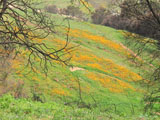
After about twenty minutes we left the developed area and almost instantly a hill covered with wildflowers suddenly came into view. Unfortunately, we didn’t have our camera but made mental notes to take it tomorrow and, for a change, take a “do-over” hike just for a picture. The terrain we were on was quite barren, but somewhat level, and eventually started leading downhill. The decomposed granite was rather large and acted like ball bearings under our feet. Amber, as well as I, seemed to have trouble maintaining footing. At the bottom of the hill, we crossed a creek lined with trees and at once found ourselves on Old Coach Trail a little north of the point on Old Coach Trail where we turned around yesterday. Our question of how far Lomas Verdes trail extended was pleasantly answered.
We continued to a fire-damaged bridge that was closed with yellow barrier tape, at which point we turned around. At the base of the hill we were to climb was a sign that suggested we not proceed, as it was sensitive habitat. So we had a dilemma-our car was at the other end of the trail and we’d seen no signs prohibiting our hiking east. It seemed odd that we could go east but not west. We did what we had to and returned to the west. As we returned, we were looking for the expected sign that warned of the sensitive habitat but didn’t find one. We did see our two dogs, only this time, friendship won and Amber and the friendly dog kissed through the fence and the snarly dog stood by quietly, but watchfully.
One would think it would be easy to follow the trail back but we missed the section of trail going south and ended up in a street, not trail, cul-de-sac. So we turned around again, looked at the map, saw the trail south but didn’t think it was the right one and continued on for a few minutes more. We then decided that even if it wasn’t the correct trail, it was heading south and that’s the direction we wanted to go. We were happy to see the muddy patch again, as that confirmed we were on the right trail.
I emailed the Poway Parks division about the sign at the east end of Lomas Verdes trail and was told that sign was meant for a northern trail (which we didn’t see) and that the Lomas Verdes trail was the southern trail and acceptable to use.
We’re looking forward to tomorrow and wildflower pictures!
We took the middle section of Twin Peaks trail (#23) this morning and it was, by far, the most rugged Poway trail we’ve taken. (We’re daily working our way through the Poway trail system.) The wildflowers, although sparse, were beautiful. At some points the trail was about a foot wide and was sometimes difficult to follow due to crossing trails and narrow access roads, apparently for the electric power lines. We twice crossed the stream at the base of the trail near the PUSD buildings and just north of Midland Road. Amber, being the wild dog that she is, didn’t stop to drink the water but quickly lapped water as she waded upstream while crossing.
When we returned day before yesterday from our walk in the rain, I dried Amber with a towel. She was lying on her side and I was carefully drying her legs, one by one, as we don’t entirely trust her. She seemed content until I started drying the last leg. She immediately reacted by jumping up, wailing and frantically putting her teeth all over my arms like she was biting but not doing so. We ended up with her standing on her back legs looking eye-to-eye with me, my left hand holding her by her collar and she showing teeth and the most gums I’ve every seen. She was one unhappy camper. As we looked at each other, her lips gradually closed and I released her collar. Scary!
Reflecting on what had just occurred, I thought that she had been abused and I had triggered an ‘anchor’ which brought back those memories. We had virtually decided to return her because we don’t need an unstable dog. She had reacted similarly when I tugged on her shoulder to get her out of the car a month or so ago. Later on in the day, when she was lying down, I noticed her dewclaws and then it occurred to me that most likely a dewclaw caught in the towel when I was drying her and she was reacting to the pain, however slight. We’re giving her the benefit of doubt, but it’s yet another instance of her being a ‘frighty’ dog.
We avoid, when we can, repeating walks with Amber in order to give both her and us new experiences. Today we explored a very narrow, unmarked trail off the horse trail in our neighborhood. We wandered through the trees and brush and ultimately came upon what was questionably a public street. Eventually, we came to a street that we recognized as being in a community from which we moved eighteen years ago.
We followed that street to an open space leading to a briskly flowing creek. The area was vaguely familiar as we last visited it about twenty-five years ago. Amber eagerly found a crossing spot and rushed across, then waited for me. We decided that we wouldn’t continue in that direction because of the terrain and and uncertainty of public/private property. Our current house was very close to where we were but it would have been a rugged hike getting there.
We explored downstream along the creek and came to a “Private Property” sign so retreated to the street and went back home the way we came.
I looked on Poway’s website for both open space and a trail map of the trails in our area but didn’t see any but the one known to us. I then called the city staff to get information and the staff were most helpful. The parks maintenance supervisor was intimately knowledgeable about the area we hiked and we found out that much of what we thought was open space was undeveloped, unposted, private property. The narrow trail that we took initially was a public easement by the tract developers to Poway to allow the Poway High School students a way to continue to walk to school. Apparently, there are numerous such unmarked trails in the area, some maintained by the city, some not.
Amber seemed very happy with the much longer than usual walk and I’m sure she’s excitedly looking forward to the next walk.